


Darjeeling Landslides: Causes, Impact & Path to Resilience

Introduction
The Darjeeling hills of West Bengal — famed for their tea gardens, panoramic views, and rugged terrain — are once again in the grip of nature’s fury. In early October 2025, heavy rains unleashed a series of devastating landslides across Darjeeling, Mirik, Kurseong, and adjoining districts. The deluge has claimed lives, destroyed infrastructure, cut off vital links, and left communities stranded.
In this article, we will explore the causes, recent episodes, impact, and future strategies related to the Darjeeling landslides. We will organize insights under headings, present data in table form, and outline key points in lists for clarity.
Understanding Landslides in Darjeeling
Why Are Landslides Frequent in Darjeeling?
Darjeeling’s topography and climatic patterns make it especially vulnerable to slope failures. Some of the main contributing factors include:
-
Steep slopes and rugged terrain: Hillsides with sharp gradients are mechanically unstable, especially under saturation.
-
Intense & concentrated rainfall: Sudden heavy downpours quickly saturate soil, reducing cohesion and triggering slides.
-
Deforestation and land use change: Removal of vegetation weakens root binding of soils.
-
Unplanned construction & road cutting: Excavation and development on fragile slopes destabilize terrain.
-
Poor drainage systems: Blocked or inadequate drainage leads to water accumulation in soil layers.
-
Seismic activity & geological fragility: The Himalayan region is seismically active, and weak zones may fail under stress.
These factors combine to create a high-risk environment, especially during monsoon or heavy rainfall events.
Types of Landslides
In Darjeeling, common landslide types include:
-
Slump or rotational slides: Curved failure surfaces, often when soil detaches and slides downward in a rotational mode.
-
Translational slides: More planar movement along weaker strata or bedding planes.
-
Debris flows: Fast-moving mixtures of water, soil, and rock which sweep downhill — often the most destructive.
-
Rockslides / rockfall: Rocks or boulders detach and slide, especially in steep rocky cliffs.
Understanding the type is vital for mitigation and rescue operations.
Recent 2025 Episode: What Happened
Timeline & Extent
| Date | Event / Trigger | Affected Areas | Notes |
|---|---|---|---|
| Oct 3–4, 2025 | Extremely heavy rainfall (> 300 mm in 12 hrs) | Darjeeling hills, Mirik, Kurseong, Jalpaiguri foothills | Intensified overnight rains triggered multiple slides |
| Oct 4–5 | Landslides in Mirik, Sarsaly, Dhar Gaon, Nagrakata | Roads cut off, homes buried, tourists stranded | Several villages disconnected |
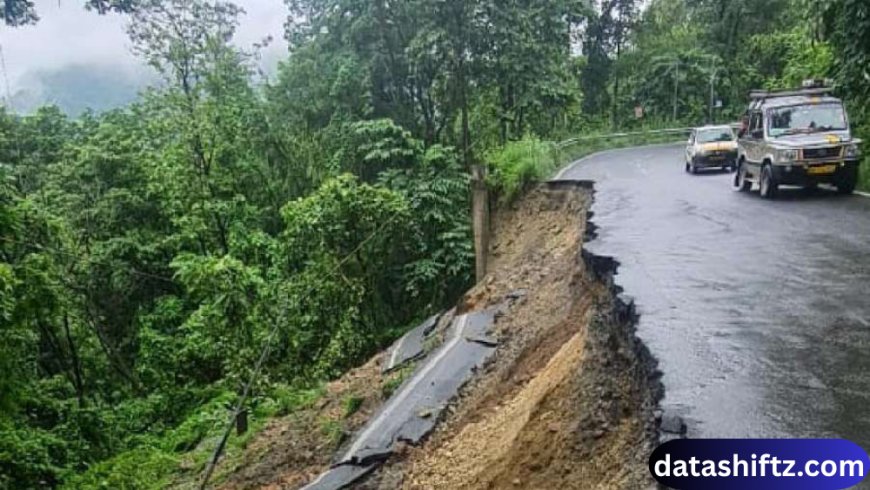
| Oct 5 | Collapse of iron bridges, road segments sink | Dudhia Bridge over Balason River, NH-110 near Kurseong | Critical link between Siliguri and Mirik lost |
| Oct 5–6 | Rescue & damage assessments | Multiple landslide points, cut-off pockets | Rescue operations by NDRF, local authorities |
Human & Infrastructure Losses
-
The death toll has risen to 24 (and possibly more with missing persons) as rescue teams continue operations.
-
Injuries & missing persons: Several injured, many yet unaccounted for.
-
Infrastructure damage: Two iron bridges collapsed, numerous road stretches washed away, interruption of National Highway links.
-
Transport disruption: Darjeeling Himalayan Railway (toy train) services suspended due to landslides near Kurseong and track disruptions.
-
Tourists & residents stranded: Many visitors and local communities are isolated in hill pockets with disrupted access.
This landslide event is being described as one of the worst in a decade for the Darjeeling region.
Impact & Challenges
Socio-Economic Impact
-
Lives lost & trauma: Beyond fatalities, families lose homes, livelihoods, and dignity.
-
Agriculture / Tea gardens: Slopes that host tea plantations suffer soil depletion, plant loss, and erosion.
-
Tourism collapse: Darjeeling’s economy depends heavily on tourism; disruption damages rural incomes.
-
Displacement: Many residents have lost houses or moved to relief camps temporarily.
-
Infrastructure strain: Costs for rebuilding roads, bridges, drainage, and slopes are considerable.
Operational & Rescue Challenges
-
Access difficulty: Remote terrain and washed roads impede rescue teams and relief supplies.
-
Ongoing rainfall: Continued rain hinders clearing operations and risks further slides.
-
Communication cuts: Cuts in power and telecom lines isolate affected zones.
-
Debris & unstable slopes: Rescue operations must navigate unsafe ground with risk of secondary slides.
Environmental & Long-Term Effects
-
Soil degradation & erosion: Loss of topsoil and destabilization of slopes for future risk.
-
Loss of vegetation: Trees uprooted reduce slope stability and recovery potential.
-
Altered drainage patterns: Channels may shift, causing future water logging or flash flows.
Response, Relief & Rehabilitation
Immediate Relief Efforts
-
Deployment of NDRF, state disaster forces, armed forces, and local teams.
-
Evacuation of stranded tourists and residents to safer zones.
-
Establishment of relief camps, medical aid, food, clean water, and emergency supplies.
-
Coordination under state & central disaster agencies, including NDMA.
Restoration & Reconstruction
-
Clearing roads, repairing bridges, deploying heavy machinery at landslide points.
-
Setting up alternative routes and temporary bypasses where possible.
-
Reconstruction of destroyed houses with safer design norms.
-
Replanting and habitat restoration to stabilize slopes.
Policy & Mitigation Measures
Some proposed or ongoing measures include:
-
Slope stabilization: Terracing, retaining walls, geotechnical reinforcement.
-
Improved drainage systems: Proper surface and subsurface drainage to avoid water accumulation.
-
Land use regulation: Restrict construction on fragile slopes, enforce safe building codes.
-
Early warning systems: Rainfall threshold alerts, slope sensors, satellite monitoring.
-
Awareness & community training: Teaching locals about landslide indicators, evacuation plans.
These strategies aim to build resilience against future disasters.
Key Takeaways
-
Intense rains triggered rare and destructive landslides in Darjeeling in early October 2025.
-
As of current reports, 24 lives lost, many missing or injured, and extensive damage to infrastructure.
-
Terrain, geology, deforestation, and unplanned construction exacerbate landslide risks.
-
Crisis response involves rescue, evacuation, relief camps, and repair operations.
-
Long-term resilience requires slope stabilization, drainage, land planning, and early warning systems.
-
The event underscores the urgent need to adapt hill region development to climate extremes.
Lessons & the Road Ahead
-
Balance development with nature: Hills are fragile — infrastructure and expansion must respect ecological limits.
-
Invest in monitoring & technology: Use geospatial tools, slope sensors, and real-time data to predict failures.
-
Strengthen institutional frameworks: Districts must have robust disaster preparedness plans.
-
Community participation: Local residents should be empowered as first responders and stewards of slope safety.
-
Policy enforcement: Building codes, zoning, and construction norms must be strictly applied.
The Darjeeling tragedy serves as a solemn reminder: climate shocks are increasing, and hilly regions like Darjeeling must build both infrastructural and social resilience.
Conclusion
The Darjeeling landslides of October 2025 are a tragic chapter in an already vulnerable region. The combination of nature’s fury and human disregard for slope stability has resulted in loss of lives and a deep wound to communities.
While immediate rescue and relief are the priority today, the long-term challenge is rebuilding smarter, safer, and sustainably. Only with integrated planning, early warning systems, local engagement, and ecological sensitivity can Darjeeling hope to mitigate future disasters of this magnitude.