Introduction
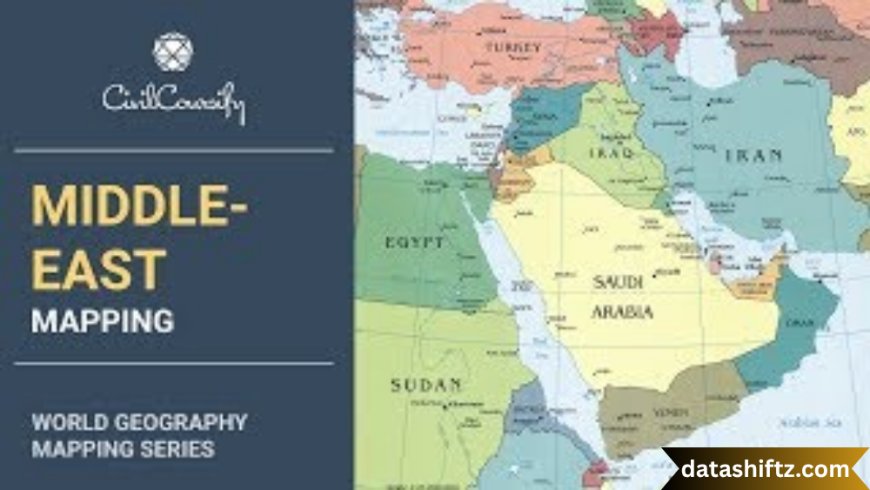
The Middle East is a region of profound historical, geopolitical, and cultural significance. Often defined by its strategic location at the crossroads of Europe, Asia, and Africa, the Middle East comprises a collection of countries with diverse ethnicities, languages, religions, and political systems. The Middle East map not only reflects national borders but also encapsulates centuries of empire, trade, war, and diplomacy.
This blog explores the geography of the Middle East, examines key countries and boundaries, provides political and cultural insights, and analyzes how modern maps are shaped by both historical legacies and current events. Through tables, lists, and structured sections, readers will gain a thorough understanding of this influential region.
Geography of the Middle East
The Middle East spans a vast area covering parts of Southwest Asia, Northeast Africa, and even parts of Southeastern Europe depending on how it’s defined. It includes deserts, mountain ranges, rivers, and coastal plains, making it a region of extreme geographic and climatic diversity.
Key Physical Features
| Feature |
Description |
| Arabian Desert |
One of the largest deserts in the world, covering much of the Arabian Peninsula. |
| Tigris-Euphrates |
Fertile river system in Iraq and Syria, cradle of ancient Mesopotamian civilization. |
| Zagros Mountains |
A major mountain range in Iran and parts of Iraq. |
| Nile River |
Though primarily in Africa, Egypt and the Nile are integral to Middle East geography. |
| Red Sea / Persian Gulf |
Vital maritime routes that influence regional trade and politics. |
Political Map – Countries and Borders
The modern political map of the Middle East is the result of both colonial-era boundary drawing and modern-day agreements. The Sykes-Picot Agreement, decolonization, oil discovery, and recent conflicts have all left their marks on current borders.
Countries Commonly Included in the Middle East
| Country |
Capital |
Geographic Position |
Notes |
| Saudi Arabia |
Riyadh |
Arabian Peninsula |
Largest country in the region by area |
| Iran |
Tehran |
Eastern Middle East |
Influential Shia-majority nation |
| Iraq |
Baghdad |
Between Iran and Syria |
Historically home to Mesopotamia |
| Israel |
Jerusalem |
Eastern Mediterranean |
Disputed capital; major regional player |
| Egypt |
Cairo |
Northeast Africa |
Cross-continental (Africa-Asia) influence |
| Syria |
Damascus |
Eastern Mediterranean |
Long civil conflict; key to regional balance |
| Jordan |
Amman |
Near Israel, Iraq, Saudi |
Stable monarchy, strategically located |
| United Arab Emirates |
Abu Dhabi |
Arabian Peninsula |
Known for economic diversification |
| Qatar |
Doha |
Gulf |
Wealthy nation, diplomacy hub |
| Lebanon |
Beirut |
Eastern Mediterranean |
Multicultural; recent economic turmoil |
| Turkey |
Ankara |
Bridge to Europe |
Eurasian identity; regional military power |
| Kuwait |
Kuwait City |
Gulf |
Oil-rich, compact state |
| Oman |
Muscat |
Southeastern Arabian Peninsula |
Peaceful and neutral in Gulf politics |
| Bahrain |
Manama |
Island in Gulf |
U.S. Naval base, Sunni monarchy |
| Yemen |
Sana'a |
Southern tip of Arabia |
Conflict-ridden and humanitarian crisis zone |
| Palestine |
East Jerusalem (claimed) |
West Bank/Gaza |
Contested statehood |
Definitions vary—some maps also include Afghanistan, Pakistan, and North African countries like Libya and Sudan.
Historical Evolution of the Middle East Map
Ancient Empires
-
Mesopotamian civilizations (Sumerians, Akkadians, Babylonians) in present-day Iraq.
-
Persian Empire—one of the largest empires stretching across Iran to Egypt.
-
Ottoman Empire—controlled much of the Middle East for 600 years until WWI.
Colonial and Post-Colonial Eras
-
Post-WWI treaties redrew boundaries (e.g., Sykes-Picot Agreement split Ottoman lands between France and Britain).
-
Creation of modern Iraq, Syria, Lebanon, Jordan under colonial mandates.
-
1948: Creation of Israel and ensuing Arab-Israeli conflict.
-
Gulf War (1991) and Iraq War (2003) further altered political realities.
Strategic and Cultural Importance of the Middle East
Strategic Importance
-
Oil Reserves: Houses over 50% of global proven oil reserves (especially Saudi Arabia, Iran, Iraq, UAE).
-
Trade Routes: Key maritime chokepoints like the Strait of Hormuz, Suez Canal, and Bab el-Mandeb.
-
Geopolitical Conflicts: Israel-Palestine, Iran-Saudi rivalry, Syria’s civil war, Yemen crisis.
Cultural & Religious Significance
-
Birthplace of Abrahamic religions: Islam, Christianity, Judaism.
-
Major holy cities:
-
Rich traditions in art, architecture, language, and cuisine.
Middle East Languages & Religions Overview
| Language |
Common Countries |
Religion Dominance |
| Arabic |
Saudi Arabia, Iraq, Syria, Egypt |
Islam (Sunni & Shia), Christianity |
| Persian (Farsi) |
Iran |
Shia Islam |
| Turkish |
Turkey |
Sunni Islam, Secular Constitution |
| Hebrew |
Israel |
Judaism |
| Kurdish |
Iraq, Iran, Turkey, Syria |
Sunni Islam, Yazidism |
Contemporary Conflicts and Shifting Borders
The Middle East map is not static. Shifting alliances, civil wars, and international interventions constantly reshape the political terrain.
Examples of Modern Challenges
-
Syria: Fragmented control zones (government, rebels, Kurdish forces).
-
Iraq: Divided between central government, Kurdish region, and remnants of insurgency.
-
Israel-Palestine: Ongoing territorial disputes in the West Bank and Gaza.
-
Yemen: North-South divide amid Houthi conflict.
These dynamics make modern Middle East mapping complex—often requiring “control maps” updated in real time.
Key Organizations Influencing the Region
-
OPEC – Oil-producing alliance influencing energy markets.
-
Arab League – Regional cooperation body.
-
Gulf Cooperation Council (GCC) – Economic and defense pact among Gulf nations.
-
UN Peacekeeping & UNRWA – Handles refugee issues and ceasefires.
-
NATO & U.S. Military – Maintain strategic presence, especially in Iraq, Syria, and the Gulf.
Conclusion
The Middle East map is more than lines and borders—it tells a story of ancient civilizations, colonial rule, oil wealth, religion, and contemporary strife. Understanding its geography and political structure is essential for grasping the region’s role in global affairs.
Whether for scholars, policymakers, students, or travelers, studying the Middle East map fosters deeper insight into global energy markets, geopolitical tensions, cultural heritage, and the ever-changing nature of conflict and diplomacy. As global powers vie for influence and local actors assert sovereignty, the map of the Middle East continues to evolve—both on paper and in practice.