


NWS Weather Update: What’s Happening Across the U.S. Today

Critical Alerts Issued by the National Weather Service
The National Weather Service (NWS) is tracking a range of severe weather conditions across the U.S. today, from excessive heat and hurricane-force winds to wildfire risks and tornado activity. These developments have triggered multiple public safety advisories, emphasizing the importance of real-time weather awareness and preparedness.
Top Stories from Today’s Weather Reports
-
Heat Advisory in Pennsylvania’s Susquehanna Valley, with real-feel temperatures peaking at 104 °F
-
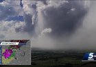
Derecho storm in the Upper Midwest, producing 99 mph winds and widespread power outages
-
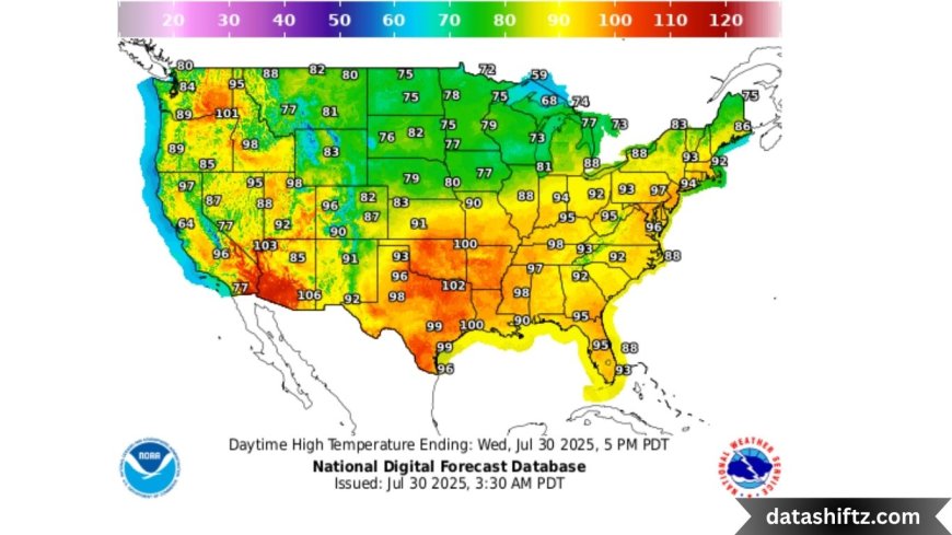
Extreme Heat Warning for over 185 million people in the Southeastern and Eastern U.S.
-
The Pentagon rescinded its plan to cut off vital satellite data used in hurricane forecasts
-
Red Flag Warning in Southern Oregon due to elevated wildfire risk from dry lightning
-
EF-0 Tornado confirmed in Wayne County, Ohio, with minor localized damage
U.S. Weather Summary: Regional Alerts & Impacts
| Location | Alert Type | Effect | Details |
|---|---|---|---|
| Susquehanna Valley, PA | Heat Advisory | Dangerous heat index up to 104 °F | Ongoing from midday through early evening |
| Midwest / Upper Plains | Derecho | Wind damage, power outages | Winds exceeded 99 mph across 240 miles |
| Southeast & East Coast | Extreme Heat | Heat illness risk, urban stress | Feels-like temps up to 120 °F |
| Gulf Coast / Coastal U.S. | Hurricane Forecasting Alert | Satellite data preserved | Pentagon maintains DMSP access until Sept 2026 |
| Southern Oregon | Red Flag Warning | Wildfire ignition risk | Lightning threat 2–11 pm in dry fuel areas |
| Wayne County, OH | Tornado Confirmation | Short-lived EF‑0 tornado | Confirmed touchdown Monday evening |
High Heat & Extreme Wind Events: What You Need to Know
Record-Breaking Heat Across the Southeast and East
Today’s heat index levels in many cities are among the highest of the year. Major metro areas in Georgia, Florida, Tennessee, and the Carolinas are facing heat index values above 115°F, posing a serious health threat. Authorities advise limiting outdoor activity and monitoring for signs of heat exhaustion.
Midwest Derecho Leaves Destruction in its Path
A powerful derecho storm system raced across Iowa, Minnesota, and parts of Wisconsin, bringing hurricane-strength winds. Trees were uprooted, buildings damaged, and large areas experienced widespread power outages, particularly in rural communities ill-equipped for sudden wind surges.
Forecast Technology Secured: Satellite Data Update
Hurricane-Tracking Data Saved by Pentagon Reversal
In a key development for weather preparedness, the U.S. Department of Defense reversed its prior decision to cut off meteorological satellite data provided by the Defense Meteorological Satellite Program (DMSP). This data is essential for overnight storm tracking, especially for hurricane formation and intensification.
Meteorologists and public safety agencies nationwide applauded the move, which preserves forecasting capabilities through at least September 2026.
Local Disruptions: Tornadoes and Fire Weather Risks
Tornado Briefly Touches Down in Ohio
The National Weather Service confirmed a small EF-0 tornado in Wayne County, Ohio late Monday evening. No major injuries were reported, but the event underscores how localized severe weather can emerge unexpectedly during broader atmospheric events.
Southern Oregon Red Flag Warning
Due to expected dry lightning strikes, NWS issued a Red Flag Warning from 2 p.m. to 11 p.m. This alert affects the Ashland region, where hot, dry conditions and wind could rapidly spark wildfires.
NWS Safety Recommendations & Public Actions
To stay safe during today’s extreme weather, follow these NWS-backed actions:
-
Avoid strenuous activity outdoors during peak heat hours (10 a.m.–6 p.m.).
-
Stay hydrated and check on elderly neighbors or those without air conditioning.
-
Secure outdoor objects and prepare for power outages if living in storm-prone regions.
-
Monitor emergency alerts and local advisories via NOAA Weather Radio or mobile apps.
-
Avoid dry brush areas and open fires in wildfire-sensitive zones.
Looking Ahead: Key Takeaways for Americans
-
The rise in excessive heat alerts is consistent with long-term warming trends. Today’s widespread heat advisories mark one of the largest heat-related warnings this summer.
-
Sudden wind events like the derecho emphasize the need for updated warning systems and rapid public communication.
-
Satellite forecasting data, particularly for hurricanes, remains secure for now, but future decisions may again impact public weather safety tools.
-
The NWS continues to deal with staffing shortages, which may affect the frequency and speed of alert dissemination. Community preparedness remains essential.
Final Thoughts: Stay Informed, Stay Safe
The National Weather Service’s active advisories today reveal how quickly weather systems can shift from inconvenient to dangerous. With millions of Americans under heat alerts, storm threats, or wildfire warnings, awareness and preparation are key.
As forecasting improves and satellite data is preserved, Americans can continue to rely on real-time updates—but individual responsibility also plays a crucial role. Know your local alerts, have a plan in place, and check on vulnerable members of your community.