


Tropical Storm Barry: Live Updates & Regional Impact
Overview and Current Status
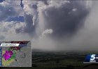
Tropical Storm Barry emerged as the second named storm of the 2025 Atlantic hurricane season. The National Hurricane Center (NHC) upgraded it on June 29, based on reconnaissance data showing sustained winds of around 40 mph with gusts reaching tropical storm strength.
Barry is centered in the Bay of Campeche, currently tracking northwest toward eastern Mexico with a movement speed of approximately 6 mph. As of 10 a.m. CDT, it's located about 90 mi ESE of Tuxpan and 165 mi SE of Tampico.
Forecast and Projected Track
According to the latest NHC advisory:
-
Expected landfall: Late Sunday afternoon or evening on the eastern Mexican coast, likely south of Tampico.
-
Forecast intensity: Slight strengthening over the warm Gulf waters, peaking around 45 mph sustained winds. Rapid weakening is anticipated once Barry moves inland.
-
Dissipation timeline: The storm is forecast to dissipate completely over the rugged mountainous terrain of central Mexico by Monday.
Meteorological Data
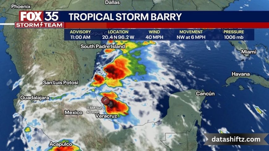
| Metric | Value |
|---|---|
| Status | Tropical Storm (second of the season) |
| Position (approx.) | 20.4°N, 96.2°W (near Tuxpan, Mexico) |
| Maximum sustained winds | ~40 mph (65 km/h) |
| Wind gusts | Up to 45 mph (75 km/h) |
| Forward speed | ~6 mph (9 km/h), northwest |
| Central pressure | ~1006 mb (29.71 in) |
| Forecast rainfall totals | 3–6 in (isolated areas up to 10 in) |
Impacts & Threats in Mexico
Tropical Storm Barry is expected to bring several hazards to eastern Mexico:
-
Heavy rainfall: Widespread 3–6 inches, with isolated pockets reaching 10 inches—sufficient to trigger flash floods and mudslides in vulnerable terrains.
-
Strong wind gusts: Up to 75 km/h (≈45 mph) near the coastline.
-
Flood and landslide risks: Particularly in hilly or mountainous regions across Veracruz, Puebla, Tamaulipas, San Luis Potosí, Hidalgo, with additional concerns in Tuxpan and Tampico.
-
Government reaction: Mexico's Civil Protection authorities have issued alerts and activated preventive protocols in affected state.
Indirect Effects on the U.S. Gulf Coast
While Barry is not expected to make U.S. landfall, its outer moisture can influence weather patterns in South Texas:
-
Increased rain chances for Houston and surrounding areas from mid‑week.
-
Temperatures in Texas remain high (upper‑80s to low‑90s °F, potentially rising into the mid‑90s).
No tropical watches or warnings are currently in effect for the U.S.
Impacts & Threats Summary
Here’s a quick overview of Barry's projected impacts:
-
Flooding: Major rainfall along eastern Mexican states – risk of flash flooding & landslides.
-
Wind: Tropical-storm-force gusts near coast.
-
Secondary U.S. effects: Enhanced rainfall in South‑Texas mid‑week.
-
Minimal direct U.S. impact: No watches or warnings in place.
What to Monitor
-
Mexico: Flood alerts, road closures, and evacuation notices in affected states.
-
U.S. (Texas): Local forecasts mid‑week; South‑Texas communities should stay informed.
-
Forecast updates: Check NHC advisories for alignment of track and rainfall distribution.
Historical Context & Season Outlook
-
Barry is the second storm of the 2025 Atlantic season, following Tropical Storm Andrea.
-
Its formation in the Bay of Campeche marks the earliest Gulf-based storm since 2014.
-
Its short life cycle—forming, reaching tropical storm level, making landfall, and dissipating within 48 hours—is consistent with Gulf storms that quickly encounter land.
If you're tracking the 2025 hurricane season, Barry serves as an early reminder of the variables that shape Gulf-based systems.
Safety Tips
Here are key safety recommendations for those in Barry’s path:
-
Avoid flood-prone areas—especially at night when flash floods occur.
-
Secure property—check drainage, reinforce windows, and trim trees.
-
Stay informed via local meteorological outlets and advisories from the Protección Civil in Mexico.
-
Avoid driving through flooded roads—just 6 inches of moving water can sweep a car away.
-
Watch for mudslides in hilly terrains—heed all local evacuation orders.
-
Prepare for power outages—have flashlights, batteries, and a 72‑hour kit ready.
-
Monitor Texas moisture mid‑week—short-term heavy rainfall can still cause flash flooding even if there's no storm.
Final Word
Tropical Storm Barry is already affecting eastern Mexico with torrential rains, gusty winds, and flood risks, and will likely dissipate over central Mexico by Monday, June 30. Though the U.S. is not in the direct path, South Texas should remain watchful for indirect weather effects mid‑week. As Barry fades, forecasters are mindful of possible new systems later in the season, especially in the Gulf.