


Tropical Storm Dexter Hurricane: An In-Depth Look at the 2025 Atlantic System

Introduction
Tropical Storm Dexter, the fourth named storm of the 2025 Atlantic hurricane season, formed unexpectedly early and drew attention primarily due to its rapid development and trajectory away from the U.S. coast. While it never reached hurricane strength, Dexter’s behavior sheds light on evolving seasonal patterns and the effects of climate change on storm formation.
This blog offers a comprehensive examination of Tropical Storm Dexter—covering its formation, projected path, meteorological context, potential hazards, and broader implications for the 2025 season. Everything is presented with structured headlines, a table, and list summaries for clarity.
Formation and Meteorological Overview
Tropical Storm Dexter developed from a stalled frontal boundary off the North Carolina coast late on August 3, 2025, and was officially designated as a tropical storm on August 4. It quickly reached peak sustained winds of 45 mph (75 km/h) and a central pressure of about 1002 mb.
Dexter formed much earlier than the climatological average for the fourth named storm (typically August 15), illustrating early-season anomalies.
Dexter’s formation was facilitated by abnormally warm seas (~29 °C, 1.5 °C above average) and low-latitude development—unusual for early August storms .
Track, Impacts, and Forecast
Dexter remained over open ocean—notably northwest of Bermuda and moving northeast at 12–14 mph. It posed no direct threat to land, though coastal regions could experience increased rip currents and high surf from New York to South Florida.
Forecasters predicted slight strengthening to near 50 mph, followed by a transition into a post-tropical cyclone by mid-week and eventual dissipation around August 9.
Key Facts About Tropical Storm Dexter
| Attribute | Details |
|---|---|
| Formation Date | August 3 (UTC), 2025 |
| Designation Date | August 4, 2025 |
| Peak Winds | 45–50 mph (75–80 km/h) |
| Pressure | Approximately 1002 mb |
| Position (Aug 4) | ~250–275 miles NW of Bermuda |
| Direction | East–Northeast at ~12–14 mph |
| Land Threat | None; remained offshore |
| Status Timeline | Tropical → post-tropical by August 6–7; dissipated ~Aug 9 |
| Main Hazards | Rip currents, hazardous seas for offshore vessels |
| Seasonal Note | Fourth named storm—earlier than typical |
Broader Context & Implications
A Season of Weak Systems (List Form)
-
Andrea, Barry, Chantal, and Dexter remain among the weakest first four storms of any season in decades.
-
Combined, their Accumulated Cyclone Energy (ACE) is far below average—just around 2.5 units versus a typical ~9.1 days of activity by early August.
-
The absence of a hurricane through early August is notable, often not the case until mid-to-late August .
Climate Linkages
-
Dexter’s development off the Mid-Atlantic suggests shifting storm genesis zones, potentially influenced by rising sea surface temperatures and changing atmospheric patterns .
-
NOAA’s forecast for 2025 anticipated 13–19 named storms, 6–10 hurricanes, and 3–5 major hurricanes, signaling a likely uptick in activity even if early storms are weak .
-
The rapid formation and high-latitude track align with trends predicted under human-driven climate warming scenarios .
Potential Risks and Why Dexter Still Matters
Even minimal storms over open water can produce hazards:
-
Marine Interests: Shipping lanes and offshore operations must monitor storm-generated waves and currents.
-
Rip Currents: Coastal beaches along the eastern U.S. may experience dangerous conditions despite no landfall threat.
-
Public Awareness: The naming and tracking of all tropical storms—regardless of strength or impact—helps reduce confusion and supports safety communication.
Forecast Ahead: What Comes Next?
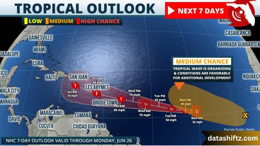
Forecasting agencies are now tracking additional disturbances:
-
A low-pressure area near the Southeastern U.S. coast, with a 30% chance of development in coming days.
-
A tropical wave off Africa, with a 50% chance of development as it moves westward into the central Atlantic basin
These conditions amplify expectations for increasing storm frequency heading into the hurricane season’s peak from mid-August to early September.
Summary of Key Points (List Form)
-
Dexter was the fourth named storm of the 2025 Atlantic hurricane season.
-
It formed unusually early and remained weak, never reaching hurricane status.
-
The storm tracked away from land, posing marine risks only.
-
Its development north of 30°N reflects shifting storm formation zones.
-
Dexter followed a string of low-ACE early-season storms, indicating a slow start.
-
NOAA and other agencies still expect an above-average season despite early weakness.
-
Additional systems with development potential are being closely monitored.
Conclusion
Tropical Storm Dexter may have been short-lived and land-impact-free, but it offers valuable meteorological insights amid a changing climate regime. As the 2025 season continues, its uneventful track may serve as a calm before the storm—literally—for what NOAA and NHC forecast as an active, energetic hurricane period ahead.
Even minor storms reinforce the importance of vigilance—with every system, public preparedness, forecasting infrastructure, and climate analysis are thoroughly tested. Stay informed, stay safe, and keep an eye on the evolving forecasts this hurricane season may bring.