


Tropical Storm Erin Today: A Powerful Atlantic Threat Brewing

Overview of Tropical Storm Erin
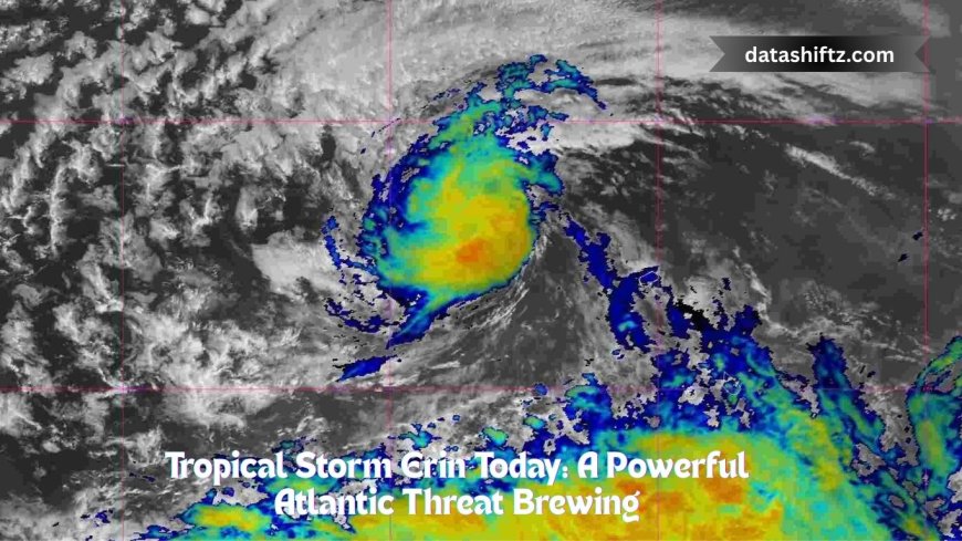
Tropical Storm Erin, the fifth named storm of the 2025 Atlantic season, has emerged in the eastern Atlantic and is poised to become the season’s first hurricane. Formed near the Cabo Verde Islands, Erin's current characteristics hint at a long-lived, potentially powerful system that deserves careful attention.
As of mid-August, Erin is moving westward at about 20–23 mph (32–37 km/h), with sustained winds near 45 mph (75 km/h). Forecasts predict gradual strengthening, possibly reaching hurricane status by mid-to-late week, and potentially becoming a major hurricane (Category 3) by the weekend.
Current Status and Forecast Track
Facts at a Glance
| Attribute | Current Status |
|---|---|
| Location | Several hundred to over 800 miles west of the Cabo Verde Islands (varying by advisory) |
| Movement | Westward at ≈20–23 mph |
| Wind Speed | Sustained winds near 45 mph |
| Forecast Intensity | Hurricane by midweek; Category 3 by weekend |
| Watches/Warnings | None currently; northern Leeward Islands, U.S. East Coast, Bermuda, and Atlantic Canada urged to monitor developments |
What Models and Forecasts Say
Forecast models show strong agreement that Erin will likely intensify over warm Atlantic waters and follow a typical North Atlantic track—curving northeast away from major landmasses. While the chance of a U.S. landfall appears low, large swells, rip currents, and coastal erosion could still affect beaches from the Caribbean up through New England.
Regional Impacts and Precautionary Measures
Where to Watch Closely
-
Cabo Verde Islands: Devastating flash floods struck São Vicente and Santo Antão, resulting in at least nine fatalities and prompting a state of emergency.
-
Leeward Islands & Puerto Rico: While no direct hits are expected, high surf, strong currents, and frequent squalls remain possible.
-
U.S. East Coast, Bahamas, Bermuda, and Atlantic Canada: Though a direct path is unlikely, the storm’s evolution warrants sustained vigilance, especially for coastal and maritime activity.
Preparedness Checklist
-
Stay Updated: Track updates from the National Hurricane Center and other trusted meteorological sources.
-
Emergency Kit Ready: Include water, non-perishables, flashlights, first-aid supplies, and secure important documents—both physical (in waterproof containers) and digital.
-
Review Insurance: Ensure policies (especially flood coverage) are active and adequate.
-
Coastal Awareness: Even without landfall, storm-driven rip currents and erosion can pose risks—especially near beaches not directly affected.
Final Thoughts
-
What’s happening: Erin is now a tropical storm, strengthening steadily over the eastern Atlantic.
-
What’s expected: Forecasts point to hurricane intensity by midweek, with some models projecting it to become a major hurricane (Category 3) by the weekend.
-
What to watch: Cabo Verde has already been hit by deadly flooding. Though current projections keep Erin offshore, heightened surf and coastal impacts are possible across the Caribbean and eastern U.S.
-
What to do: Monitor updates, prepare emergency supplies and documents, and stay alert to local advisories.