


Tropical Storm Erin Today: Latest Development and Forecast

Tropical Storm Erin has emerged in the eastern Atlantic, captivating meteorologists and coastal communities alike. As the fifth named storm of the 2025 Atlantic hurricane season, Erin is tracking westward and is poised to become the season’s first hurricane, possibly reaching major hurricane status by the end of the week. This blog post provides the latest updates, forecast outlooks, and practical insights for preparedness.
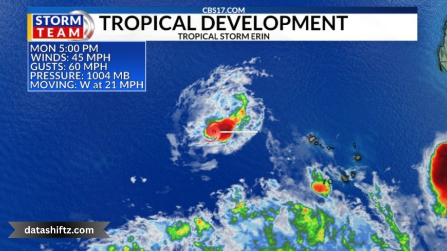
Formation and Early Impact
Erin formed early Monday morning just west of the Cabo Verde Islands, marking an early start compared to the usual timing for the first hurricane of the season . At the time of formation, the storm was located approximately 280 miles west-northwest of the Cabo Verde Islands, moving west at around 20 mph, with maximum sustained winds of 45 mph .
The storm's precursor brought deadly flooding to the island of São Vicente, where six fatalities were reported, including four children. The weather event caused widespread damage to infrastructure, roads, and housing .
Stats at a Glance
| Attribute | Details |
|---|---|
| Current Position | ~280–430 miles WNW of Cabo Verde |
| Movement Speed | ~20–22 mph westward |
| Sustained Winds | ~45 mph (tropical storm strength) |
| Intensification | Expected to become hurricane mid-week |
| Local Impacts | Flooding and damage in Cabo Verde |
Forecast and Projected Path
Strengthening Trend
Meteorologists from the National Hurricane Center (NHC) forecast that Erin may become the first hurricane of 2025 by mid-week, with the potential to intensify to Category 3 (major hurricane) by the weekend . Environmental conditions, including favorable wind shear and rising humidity, support this intensification trend . Some models suggest that Erin could take a very long track—spanning approximately 3,000 miles over two weeks .
Track & Possible Impacts
Despite Erin’s journey beginning near the Cabo Verde Islands, no immediate coastal watches or warnings have been filed for the United States, Caribbean, or Bahamas yet . Forecast panels indicate a likely west to west-northwest track across the tropical Atlantic .
-
Barbados and Lesser Antilles: Not expected to be impacted directly; Erin is forecasted to pass well to the north .
-
U.S. East Coast and Gulf Coast: Current modeling suggests little threat to Texas or the Gulf Coast, although a trajectory toward the eastern U.S., Bahamas, or Bermuda remains plausible depending on how Erin interacts with the Bermuda High and mid-latitude weather systems .
Preparedness and Potential Scenarios
Recommended Preparations
Although Erin is not an immediate threat, authorities and forecasters advise vigilance. Preparedness steps include:
-
Monitoring the storm’s progress via reliable sources like the NHC and local meteorological agencies.
-
Reviewing and updating emergency preparedness plans (e.g., evacuation routes, supplies).
-
Securing properties and monitoring alerts if you live in coastal regions.
Potential Scenarios
-
Rapid Intensification and Northward Turn: Erin becomes a major hurricane and curves north toward Bermuda or out to sea.
-
Gradual Shift Northwest: The storm gains strength and potentially threatens the Leeward Islands, Bahamas, or eastern U.S.
-
Westward Track Without Landfall: Erin remains over open ocean, primarily of concern to maritime interests and distant coastal areas.
Quick Summary
-
Formation: Early Monday near Cabo Verde Islands.
-
Current Strength: Tropical Storm with ~45 mph winds.
-
Trajectory: West to west-northwest across the Atlantic.
-
Forecast: Potential to become a hurricane mid-week and major hurricane by the weekend.
-
Land Threats:
-
Immediate: Minimal for Barbados, Lesser Antilles, or U.S.
-
Later: Possible threat to Caribbean or U.S./Canadian East Coast, depending on trajectory.
-
-
Action Items: Stay informed and remain prepared, especially if you reside in eastern coastal areas.
Conclusion
Tropical Storm Erin represents a significant development in the Atlantic hurricane season, with strong indicators it could escalate to a major hurricane. Its early formation and intensification path highlight the importance of careful monitoring, even when immediate threats seem minimal.
Stay tuned to updates from the NHC and trusted meteorological outlets. Readiness now can make all the difference several days down the line—especially for communities that might eventually feel its impact.